[dropcap letter="E"]
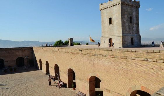
n the watchtower of Montjuïc Castle, a plaque evokes Pierre Méchain. At the other end of the city, in Plaça de les Glòries, stands the meridian monument that depicts the Earth's profile from Dunkirk to Barcelona. What do these two unconnected reminders have in common? They connect the Catalan capital with one of the most incredible adventures of modern science: the establishment of a universal measure, the meter. The Paris Academy of Sciences approved on March 19, 1791, the new measure, which represents the ten-millionth part of the quadrant of a terrestrial meridian. To determine this distance, it was necessary to measure the part of the meridian between Dunkirk and Barcelona. Astronomers Pierre Méchain and Jean-Baptiste Delambre were in charge of this task. Delambre measured the northern section, but Méchain got the most dangerous part: Rodès-Barcelona.
The Spanish King Charles IV allowed Méchain to operate in his territory, and the geographer went through all kinds of adventures in his objective of measuring geodesic triangles to determine the curvature of the Earth.His feat is known in scientific circles. However, the vision held in late 19th-century France, a period of inventive effervescence and rapid advances, may not be as well known. It is at this point that I would like to explore the account given by W. de Fonvieille (Paris, 1824-1914), a kind of Carl Sagan of the era. The conquest of the North Pole, hot air balloons, electricity: in short, the "miracles" of science are some of the themes that populate his works. In The measurement of the meter, dangers and adventures of what determined it (1886), available in the prodigious Gallica, Fonvieille gives colorful details about Méchain's epic, who carried out his campaign in the midst of the French Revolution. The expedition had a political dimension, as it laid the foundations for a new era. "Obtaining the measure of the meter was indispensable to erase the traces of the Ancien Régime and complete the innovative system that also integrated the calendar and revolutionary festivals," says Fonvielle. But while winds of liberty, equality, and fraternity blew in France, the Spanish king Charles IV, cousin of Louis XVI, did everything possible to stop the ideas coming from Paris. However, he allowed Méchain to work in his territory.
The geographer arrived in Barcelona in July 1792 after overcoming several obstacles. Here Fonvieille adds his flavor: at the border, the Miquelets kidnap his assistant, Tranchot, who is finally freed in Perpignan; he remains convalescing for five months in Caldes after suffering a serious accident with a hydraulic machine, has economic problems and, when the French king is guillotined on January 21, 1793, he is trapped in Catalonia. A hostage of the captain general, Méchain cannot leave the country at war, but he can continue his operations. Finally, he is granted a safe-conduct to travel to Italy, risking himself in a Mediterranean infested with pirates. From Genoa, he returns to France and in three years concludes the measurements of the geodesic triangles of the French part. At the end of August 1798, Méchain and Delambre meet in Carcassonne and share their calculations. A year later they sign the final report. But the adventure does not end here, because they decide to extend the measurements to the Balearic Islands to be able to determine —according to Fonvieille— the curvature of the Earth. So Méchain returns to Catalonia.
"I have decided to remain in this horrible exile, far from what I love most in the world. I sacrifice it and give up everything before returning without having finished my part of the work," Méchain laments to the Paris Metro Commission. With Napoleon's rise to power, the project was on the verge of collapse. The Empire was not so enthusiastic about the "revolutionary measures," but allowed —with the permission of Charles IV— to continue with the measurements of the meridian arcs in the Islands. On the trip to Cabrera, Méchain almost shipwrecked. To make matters worse, the islanders do not allow the crew to disembark for fear of yellow fever, which is wreaking havoc. When they are finally allowed to disembark, he realizes that no mountain serves him for his calculations and, furthermore, he falls into a torrent and ends up injured. Méchain no longer has any doubt, he is a true "martyr of French geodesy."
Next, the scientist embarks for Valencia in April 1804 to unite the coastal chain with the islands via Ibiza and Cullera. He is welcomed by the Baron of Pobla Tornesa, in whose arms he will die shortly after, on September 20, of yellow fever. "When they thought him safe, he relapses because, driven by his fatal passion, he gets up at night to observe the stars," Fonvielle points out. "My wife, my children... triangle!" were his last words.
Today, as we measure objects with mobile applications, or quantify our physical activity with the distances the device calculates for us, we would do well to remember more scientists who, like Méchain, went into exile and lived a thousand adventures, overcame seemingly insurmountable obstacles, and even lost their lives to advance an inch in the knowledge of the earth.
Add The New Barcelona Post as your preferred Google source for free
Stay informed with the latest news.